

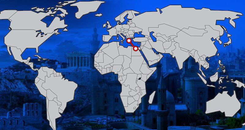
The Exclusive Economic Zone (EEZ) agreement between Athens and Cairo caused great discomfort, especially in Greece. For days, the Greek press has covered how ‘Greek rights’ were presented. Intense objections arising over the agreement show that the approval process in the Greek Parliament is also subject to serious debates. The agreement of two countries with such a push, which has no opposite coast, has never been seen in world history. Despite this, it seems that much more reasonable agreements have not been ratified. The Exclusive Economic Zone agreement signed between the Greek Cypriot Administration of Southern Cyprus (GCASC) and Lebanon was one of them.
WHAT WAS GREECE’S THESIS?
First of all, it is necessary to understand the basis of Greece’s maximalist claims. At the root of the Greek claims lies the thesis that is an “Archipelagic State”. Article 46 of the United Nations Convention on the Law of the Sea stipulates that an “archipelagic State” means a State “constituted wholly by one or more archipelagos and may include other islands”. In other words, in order for a country to become an “Archipelagic State”, it must be completely or largely composed of islands. Various examples such as Indonesia, Sri Lanka, Cuba, and the Philippines have been registered by the United Nations. But Greece is not an “Archipelagic State”, contrary to how it might seem.
Only 17% of the country’s surface area consists of islands, islets and cliffs. In UNCLOS, in the decisions of the International Court of Justice and the Arbitral Tribunal, there is no principle or decision that will make Greece an “Archipelagic State”. The thesis of Greece that “we are conducting most of our economy from the islands” has not been legally determined by such a criterion. So Athens claims are in vain.
https://uwidata.com/12453-is-greeces-plan-to-go-to-the-hague-with-egypt-over-meis-island-realistic/
WHAT DOES BECOMING AN ARCHIPELAGIC STATE MEAN?
The definition of the maritime borders of an “Archipelagic States ” is also set in article 47 of UNCLOS. According to this, “An archipelagic State may draw straight archipelagic baselines joining the outermost points of the outermost islands and drying reefs of the archipelago provided that within such baselines are included the main islands and an area in which the ratio of the area of the water to the area of the land, including atolls.” Based on these statements, Greece argues that the most extreme points of its borders are Crete, Kerpe, Kasot, Rhodes and Meis, and that it can make a deal with other countries on a midline basis by drawing a border over this line. What is worse, it adopts all the water between the islands as its own internal water. Not to mention the claim that each island has its own Exclusive Economic Zone.
WHY IS TURKEY RIGHT?
The methodology for determining the maritime boundaries was formed as a result of the Law of the Sea and the decisions of the Court of Justice and the Arbitration Court. The common point of these three authorities is that equity, equal distance, proportionality, superiority of geography, non-closure, special and human conditions and other conditions should be evaluated in determining the sea border. In other words, while drawing a border; the answers to questions such as ‘Are you preventing another state from entering the open seas’, ‘Is there a proportionality between the length of the opposite coasts and the middle line’, ‘Is there a fair agreement?’ are sought. Greece’s claims literally imprison Turkey within the Gulf of Antalya, reducing Turkey’s 189 thousand square kilometers in the eastern Mediterranean area to 41 thousand square kilometers of maritime jurisdiction. This is not fair for a country with the longest coast of the Eastern Mediterranean, at all!
WHERE DID ATHENS GO WRONG?
Athens made a big mistake first in the Exclusive Economic Zone agreements it signed with Italy and then with Egypt. Greece, which gave up its claim of “full effect on the islands” in the Italian agreement, underlined this withdrawal with thick lines in the Egypt agreement. Thus, it first abandoned the thesis that it was an ‘Archipelagic State’ and that all of its islands produce their own EEZ. In the agreement between Greece and Egypt, the border lies approximately between longitude 26 ° 00 ’00 “D and longitude 28 ° 00′ 00” D. Meis Island was never taken into account in the aforementioned agreement. Half effect has been given to Rhodes. In other words, Greece seems to have tacitly accepted that 28 ° 00’00 “E longitude constitutes the eastern border, granting half effect to Rhodes and surrounding Meis by its territorial waters. More importantly, with this agreement, the possibility of the Greece-Southern Cyprus delimitation agreement becomes history, because Greece has determined the eastern border of the continental shelf. [1]
THE EAST-MED PIPELINE WILL BE IN THE SOUP
With this agreement, the East-Med pipeline project, which is planned to transport Israeli gas to Europe via the Peloponnese, will also be in trouble, because the pipeline, which is supposed to pass through the GCASC-Greece EEZ border, will enter into Turkish sovereignty areas since such a line is no longer established. Thus, the possibility of the line to reach the continental shelf of Greece without the permission of Turkey has disappeared. Receiving permission from Turkey for the passage of the pipeline is meant to recognize the Turkish Exclusive Economic Zone. To materialize such an expensive and unfeasible project, and to obtain permission from Turkey will essentially mean the collapse of the Greek dream.
MIDDLE-LINES HAVE BEEN ABANDONED
In the agreement, Greece gives up its imposition of middle lines. The border drawn is 35 kilometers north of the middle line drawn between Rhodes, Kasot, Kerpe, Crete Islands and the Egyptian coasts. In other words, Egypt stated that the shores of the Greek islands are short against their own long coasts and asked the middle line to be drawn to the north. The same principle also applies to Turkey having long coasts up to Egypt. The coastline of Crete, Kerpe, Kasot and Rhodes overlooking the Eastern Mediterranean is 167 kilometers.
Turkey, meanwhile, has a 1870 kilometer long coast there. In addition, it was confirmed over Meis that the islands on the opposite side should be surrounded by territorial waters. In other words, Greece is shooting itself in the foot for a second time.
IRONY IN ATHENS
Athens gave Egypt ‘concessions’ due to its opposition to Turkey. Hundreds of comments have already been made describing this agreement as a ‘betrayal’, which is rather ironic. The nation has been dragged into an unfounded and unlawful adventure, mistaking it for ‘patriotism’. Essentially, such large and hollow words were uttered that a whole nation was imprisoned in them. Giving up these maximalist claims paves the way for a change of government. The Greek Government, on the other hand, is partially owning up to its mistakes by making the situation intractable with brand new ones. This discussion naturally raises more questions.
TURKEY’S POSITION
Despite the fact that terms of the Greece-Egypt agreement are invalid for Turkey, Greece’s ‘concessions’ have been noted by Ankara. Turkey, which is rather strong in the field today, does not want to play such a game. As a matter of fact, the partial effect on the islands in the Italy-Greece agreement were also recorded by the Turkish authorities. Turkey’s Exclusive Economic Zone in the field is more or less being drawn in steel. Here, Turkey’s biggest trump card is that it has handed over the coordinates of the “Maritime Jurisdiction Limitation Agreement” signed with Libya to the United Nations. In terms of international law, there is no authority that can disrupt or ignore this agreement.
[1] https://www.aa.com.tr/tr/analiz/yunanistan-misir-anlasmasiyla-akdenizde-haksizliginitescil-etti/1937166